Switzerland Rail Passes and Train Tips
By Rick StevesAre rail passes a good value for Switzerland?
Rail passes are almost always a smart buy for Switzerland, with its fairly high pay-as-you-go ticket costs and excellent transportation system. The Swiss Travel Pass is a particularly good deal, as it covers nearly all transport in Switzerland — not only trains, but buses, boats, and many high-mountain lifts.
How do I see whether a rail pass makes sense for my trip in particular?
Train Fares: Switzerland
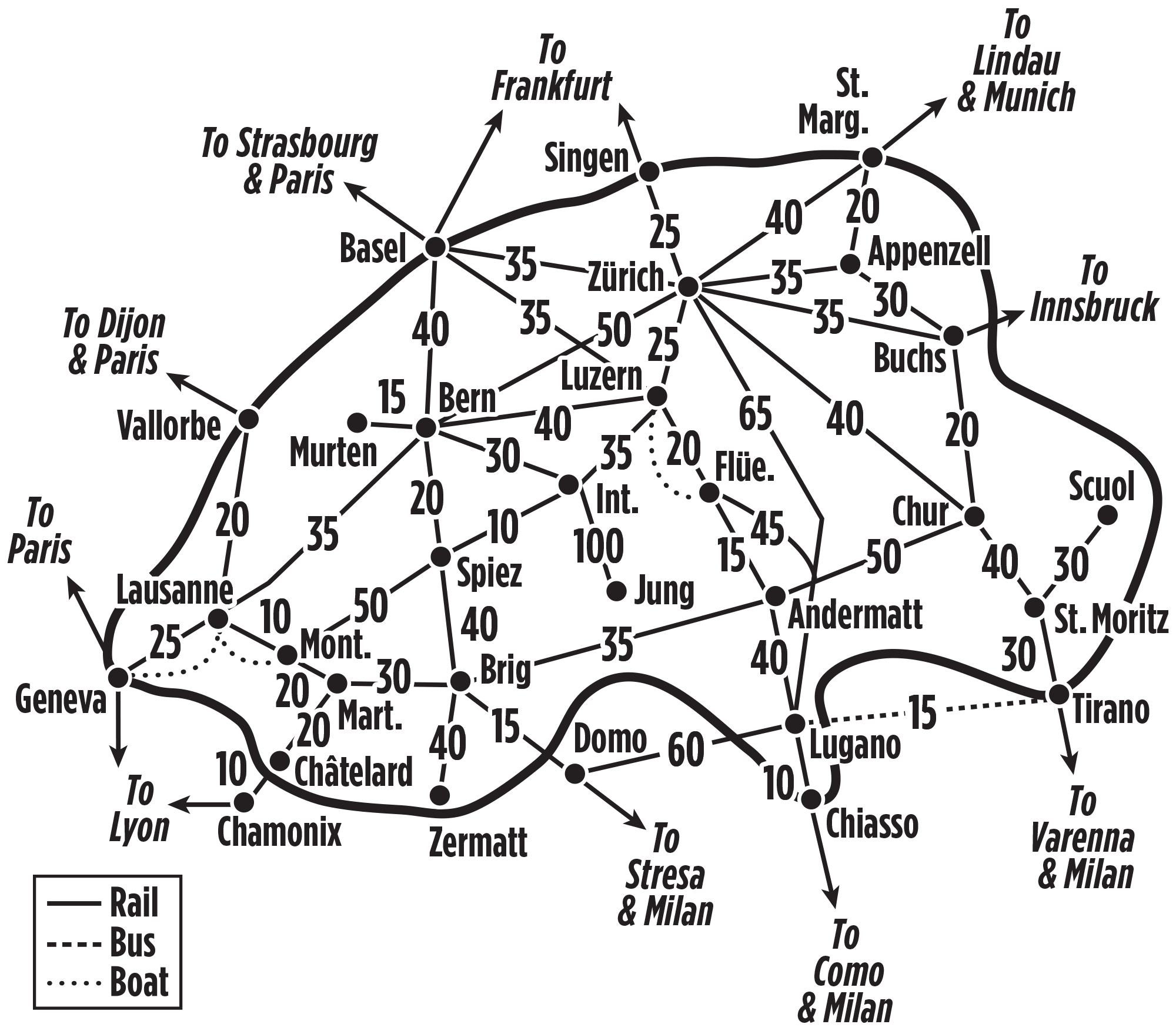
Use this map to add up approximate pay-as-you-go fares for your itinerary, and compare that cost to the price of a rail pass for the number of days you expect to spend on the train. (The dashed Lugano–Tirano line shows a popular bus connection that's covered by rail passes; dotted lines show two popular boat routes — covered by some passes.)
Also, follow the links below for:
• More tips for figuring out whether a pass makes sense for your trip
• The basics on choosing among rail passes
• More tips on how to save money by fine-tuning your rail pass
• Advice on deciding between first and second class
• Fare-estimate maps outside Switzerland
• Answers to frequently asked rail-pass questions
What are my options for rail passes that cover Switzerland?
(33 countries) → read more about this pass
►Rail Europe shopping cart: Have an order underway? Review and complete it here.
Extra tip: If your trip is primarily Swiss-focused, with just one or two train rides elsewhere in Europe, consider getting a Swiss Travel Pass (which offers far better coverage of Switzerland than a Global Pass) plus separate point-to-point train tickets (usually cheapest if booked in advance online). Note that on direct TGV Lyria trains between France and major Swiss cities seat reservations are required, and fairly expensive (about $35 in second class or $70 in first, in addition to a Eurail Global Pass) — and only a certain number are made available to passholders for any given train. (And 26/27-year-olds should note that the Swiss Travel Pass's youth cutoff is 26, whereas the Global Pass grants discounts to all travelers under 28.)
Do I need to make seat reservations on Swiss trains?
For the most part, you can hop on nearly all Swiss trains with just your rail pass in hand. Designated scenic routes (those with names, such as the Glacier Express), and some international trains (such as to/from France and Italy or night trains through Germany) do require paid seat reservations, as indicated in online train schedules.
What do rail passes cover in Switzerland?
Passes cover nearly all Swiss trains. Even specially designated scenic routes are covered, including the entire route of the Glacier Express. Any pass that covers Switzerland also covers these two Swiss-run services through Italy: Brig–Domodossola–Locarno trains and Lugano–Tirano by Bernina Express bus. Many high-mountain routes, however, such as those served by the Berner Oberland's Jungfraubahn, are only partially covered, and discounts vary depending on what kind of pass you have.
Note: As is true on any European rail pass, "covered" services, including museum admissions, require use of a counted travel day on a flexipass. Discounts generally do not (as is the case with the Global Pass), but the Swiss Travel Pass is an exception: Discounts on high-mountain lifts and trains are only available on the counted travel days of this pass.
The Eurail Global Pass offers the following discounts in Switzerland, among others:
- Berner Oberland: 25 percent off trains and lifts above/beyond Wengen/Grindelwald, and 25 percent off other travel above/beyond Lauterbrunnen (e.g. to Mürren; without this discount tickets cost, from Wengen, about $200 round-trip to the Jungfraujoch in high season; without a rail pass the cable car to the Schilthorn peak is about $105 round-trip from Stechelberg, $85 from Mürren)
- Mt. Pilatus: 50 percent off all trains and lifts above Kriens/Alpnachstad (full price: $70 for two legs)
- Mt. Rigi: 50 percent off all trains and lifts above Vitznau/Arth-Goldau/Weggis (full price: $25–40 per leg)
- Lake boats: 50 percent off most boat trips, but Lake Thun and Lake Brienz boats are fully covered
- Free kids: Up to two kids age 4–11 travel free with each adult-rate pass
The Swiss Travel Pass covers much more (see coverage map):
- Berner Oberland: All trains and lifts up to Mürren are covered (as are trains up to Wengen/Grindelwald); grants 50 percent off the Schilthornbahn cable car above Mürren, and 25 percent off lifts and trains above Wengen and Grindelwald
- Zermatt: 50 percent off lifts and trains above Zermatt
- Mt. Pilatus: 50 percent off (same as the Global Pass)
- Mt. Rigi: Covered (all trains and lifts)
- Lake boats: Covered
- Postal buses (which go just about everywhere trains/lifts don't): Covered
- Urban transit (e.g. trams and city buses): Covered
- Museums: Mostly covered (the Swiss Travel Pass is valid as a full-fledged Swiss Museum Pass, which includes admission to hundreds of Swiss museums)
- More free kids: With the Swiss Family Card, available free by request when ordering a single-country Swiss rail pass, kids age 6–15 can travel free with a parent
- Liechtenstein: A Swiss Travel Pass even covers bus travel in Liechtenstein. Go nuts!
Any tips for buying point-to-point train tickets (or other local offers) in Switzerland?
If a rail pass doesn't pencil out for your trip, you may be able to shave off the cost of your train tickets with some of these deals:
- One-month Half-Fare Card: If your Swiss travel adds up to more than $280 in point-to-point tickets within a one-month span (not a calendar month), this can save you money: It gives you 50 percent off on all Swiss trains (including private railways and high-mountain routes, including the Jungfraujoch), postal buses, city trams and buses, mountain lifts, and lake and river boats. Buy it here (it appears as an option after hitting "Search" on a Switzerland pass); also available at Swiss train stations for about the same price.
-
Berner Oberland Pass: Covers the entire Bern–Interlaken–Luzern area — but costs almost as much as a full Swiss Travel Pass. The highest mountain lifts are either 50 percent off during the validity of the pass, or have special prices (for example, the train to the Jungfraujoch is 25 percent off above Wengen or Grindelwald). Parts of the Glacier Express and Golden Pass scenic routes are also discounted 50 percent; see coverage map). This pass now completely covers the cost of the Schilthornbahn cable car, including the sections above Mürren.
The Berner Oberland Pass costs 25 percent less for those with a Swiss Travel Pass or Half-Fare Card (but it makes little sense to double up on these passes). Kids under 16 can travel with adults on this pass with the purchase of a 30 CHF per-child card that works much like the Children's Co-travelcard described above. - Kids: The Junior Travelcard and the similar Children's Co-travelcard let kids 6–15 travel free, either with a parent or grandparent (on the Junior Travelcard) or with an any adult (Children's Co-travelcard). The Children's Co-travelcard costs 30 CHF per child (up to four children per adult), whereas the Junior Travelcard is 30 CHF for one child, and 60 CHF for two or more kids. Both cards are valid for a year and sold at Swiss train stations. In Switzerland, all kids under 6 ride free without a ticket (in most of Europe, train travel is free only for kids under 4).
- Regional passes: While available for many Swiss districts, these make sense only for the rare traveler who's doing a lot of very time- and region-concentrated travel. For most travelers, the only one of these worth considering is the Berner Oberland Pass, described above.
- Advance purchase: You can cut some ticket prices by half by buying a Supersaver ticket online for a pre-selected date and time (seats are limited and refund restrictions apply).
- Advance-purchase one-day pass: The Saver Day Pass is essentially a one-day Swiss Travel Pass sold at rates that can be even cheaper, per day, than some of the shorter versions of the Swiss Travel Pass — provided you buy it far enough ahead. Most travelers doing significantly long train rides on at least three days will find the Swiss Travel Pass a better buy, but if you know your travel dates far in advance, and don't expect to be taking long trips on Swiss transport on more than a few days, it's worth checking prices and availability of the day pass for the date(s) you'd use it. Saver Day Passes are available six months out, when prices are lowest (52 CHF in second class, 88 CHF in first) — but the passes are nonrefundable, quantities are limited, and prices go up as availability drops (up to 120 CHF in second, 200 in first; passes must be bought at least one day in advance, but may sell out well ahead). As with point-to-point tickets, having a Half-Fare Card that'll be valid on your travel day cuts the going price of a Saver Day Pass by 50 percent. Also note that while the day pass covers the full price of the same trains, buses, boats, and lifts that the Swiss Travel Pass does, it doesn't grant any discount on the highest mountain transport (e.g., in the Berner Oberland, above Mürren or Wengen/Grindelwald), nor cover any museum admissions.
Swiss train tickets are easy to buy in stations or online through the Swiss Federal Railway (SBB) site. (If you do buy them online, be aware that the "from" fares displayed on the first screen of the SBB ticket shop are the prices you can get if you have a Half-Fare Card. Without that, you'd choose a rate with "no reduction.") Though tickets for some mountain-excursion trains are sold in advance (such as for the Gornergrat Railway above Zermatt), there's no need to buy these before you leave home. Also see our general tips for buying point-to-point tickets.