The Dingle Peninsula: Pure Ireland
By Rick Steves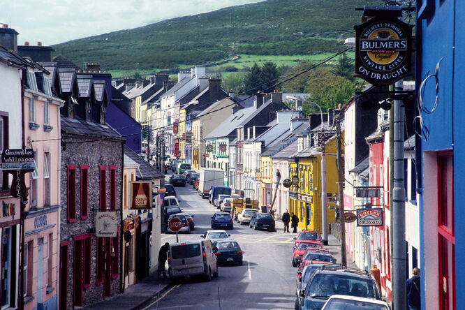
In Ireland, you drive on the left. For that reason, I take my time in a car there, especially when doing a do-si-do up and over scenic mountain roads. I slowly weave down the dramatic Conor Pass, spilling out into the rugged Dingle Peninsula. My Irish dreams have long been set in this lush spot, and I recently went back for a long-overdue visit. I'm excited to be enveloped again by forty shades of Irish spring green.
Dingle is Ireland's westernmost peninsula. (Residents are fond of saying, "The next parish over is Boston.") It's a scenically gorgeous area perfectly suited to long walks and bike rides, and it's dotted with fascinating remnants of prehistoric Ireland. It feels remote, and it is — but its little main town, also called Dingle, has everything you might need. The only downside seems to be the 100 inches of rain that falls each year.
Fishing once dominated Dingle, and the town's only visitors were students of old Irish ways. But tourists and movie makers are well onto Dingle now. Though not the first major film to feature Dingle, the filming of a recent Star Wars movie at the tip of the peninsula has once again put this Irish paradise on the big screen. What had been a trickle of fans grew to a flood, as word spread of Dingle's musical, historical, gastronomical, and scenic charms.
Dingle feels so traditionally Irish because it's part of a Gaeltacht, a region where the government subsidizes the survival of the Irish language and culture. While English is everywhere, the signs, chitchat, and songs come in Gaelic. Even the local preschool boasts that it's "All Gaelic."
The town's personality is also fueled by the steady nocturnal beat of Ireland's best traditional music scene. Locals claim that Dingle, with dozens of pubs for its 1,300 residents, has more watering holes per capita than any town in Ireland.
Foxy John's is one of several Dingle pubs with a dual identity. By day it's a handy hardware store but after hours, it's a pub. It's great for craic — that's pub lingo for conversation. If you sit at a table, you'll be left alone. Stand or sit at the bar, though, and you'll be engulfed in conversation with new friends. And if you need a hammer or some hedge clippers, the bartender is there to help.
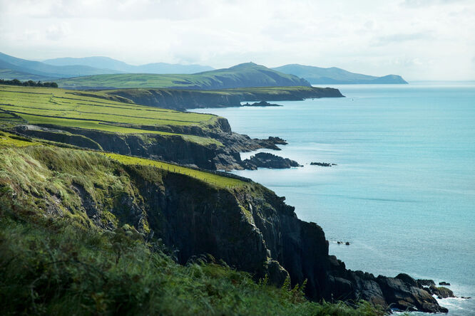
The peninsula is just the right size for a day-long driving tour (it's about 30 miles around). Circling these roads is like a trip through an open-air museum. The landscape is littered with monuments left behind by Bronze Age settlers, Dark Age monks, English landlords, and Hollywood directors.
Talk with the chatty Irish you'll encounter along the roadside. I once met an elfish, black-clad old man in the little town of Ventry. When I asked if he was born here, he breathed deeply and said, "No, 'twas about six miles down the road." I asked if he'd lived there all his life. He said, "Not yet."
The wet sod of Dingle is soaked with medieval history. In the dimmest depths of the Dark Ages, peace-loving, bookwormish monks fled the chaos of the Continent and its barbarian raids. They sailed to this drizzly fringe of the known world and lived their monastic lives in lonely stone igloos or "beehive huts," which you'll see dotting the landscape.
Parts of the peninsula are bleak and godforsaken. Study the highest fields, untouched since the planting of 1845, when the potatoes never matured and rotted in the ground. You can still see the vertical ridges of the potato beds — a reminder of that year's Great Potato Famine, which eventually, through starvation or emigration, cut Ireland's population by half.
Rounding Slea Head, the point in Europe closest to America, the jagged coastline offers smashing views of deadly black-rock cliffs and the distant Blasket Islands. The crashing waves surf in like white horses.
The tip of the peninsula is marked by a crucifix. It faces the sea, but about half the time, it's actually confronting an impenetrable cloud and whipping sheets of rain. I imagine that Dingle cows have thicker eyelids, evolved over the centuries to survive sideways rain.
The Gallarus Oratory, a 1,300-year-old stone church, is famously watertight — except when the rain is hosing in sideways from high winds. I've been splattered inside. I've driven over Conor Pass with the visibility at zero, ragamuffin sheep nonchalantly appearing like ghosts in the milky cloud. I've huddled, awaiting a chance to step out, in farmhouses abandoned in the Great Famine. Yes, the weather is a force on the Dingle Peninsula. But when the sun does come out, everything rejoices.