Navigating Europe by Car: Apps, Maps, and Trip Tips
By Rick Steves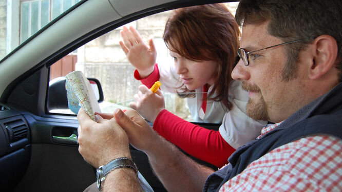
Mapping apps have taken much of the pain out of finding our way on road trips. But what about when we're overseas, where a phone connection might not be all that cheap, or fast? No road trip is without its wrong turns — but deciding on the best map apps, whether to use a GPS device, and arming yourself with some key tips for navigating in Europe can go a long way toward saving time and frustration.
My best tip for navigating unfamiliar terrain: Don't rely blindly on your phone's mapping app or a GPS device for directions; always have at least a vague sense of your route, keep a paper map handy, and pay attention to road signs so you can consider alternatives if you feel the GPS route is Getting Pretty Screwy.
Maps and Apps
Whether it's a map app on your phone or an old-school driver's atlas, a well-designed map of any kind is a must-have on any European road trip.
Mobile Mapping Apps
The mapping app on your phone works fine for navigating Europe's roads. The downside is that to get real-time turn-by-turn directions and traffic updates, you'll need internet access (a concern abroad, where you may be paying more for data).
For most travelers concerned about data roaming, the best option is an app that works offline: Google Maps, Here WeGo, and Navmii give you turn-by-turn voice directions without a data connection — and if you make a wrong turn, will recalibrate and send you on the right way. They're basically a GPS system on your phone, for free.
To use one of these apps offline, download your map before you head out (it's smart to select a large region). Then turn off your cellular connection so you're not charged for data roaming. Call up the map, enter your destination, and you're on your way. For the best performance in Google Maps, use standard view (not satellite view).
Be aware that the traffic setting on Google Maps does not work offline, so check for slowdowns and detours before you hit the road, or use data roaming for a brief period to get current conditions.
GPS apps from TomTom, Garmin, CoPilot, and others work offline but can be expensive. Mobile apps like Waze require a data connection to provide live traffic and construction updates for your route.
No matter which app you choose, bring a car charger for your device: Mapping apps gobble up battery life, even offline.
Most newer rental cars are equipped with a USB port so you can run your phone's GPS through the dashboard display, but it can also be smart to bring a clip-on car mount.
GPS Devices
Most rental cars come equipped with a GPS device in the dash; if not, you can generally rent one for about $15–20 per day. It'll give you real-time turn-by-turn directions and traffic without the data limitations of a phone app. Note that the unit may come loaded only with maps for its home country; if you need additional maps, ask when you rent. Also make sure the device is set to English before you drive off.
Paper Maps and Atlases
Even when navigating primarily with a phone app or a GPS device, I always have a paper map on hand. It's invaluable for getting the big picture, understanding alternate routes, and filling in when my phone runs out of juice.
The free maps you get from your car-rental company usually don't have enough detail. Better maps and atlases are sold at European gas stations, bookshops, newsstands, and tourist shops. Michelin offers good individual regional maps and road atlases for each country (with good city maps and detailed indexes). Atlases are compact, a good value, and easier for drivers to use than big foldout maps.
Sometimes the best regional road maps are available locally. For example, if you're exploring your roots in the Norwegian fjord country, Cappelens Damm 1:200,000 maps are detailed enough to help you find Grandpa Ole's farm. Other quality European brands include Hallwag, Freytag & Berndt, Marco Polo, AA (Britain's AAA-type automobile club), Road Editions (for Greece).
Smart Navigation
Your trip will go more smoothly if you familiarize yourself with the quirks of navigating in Europe.
Signs and Symbols
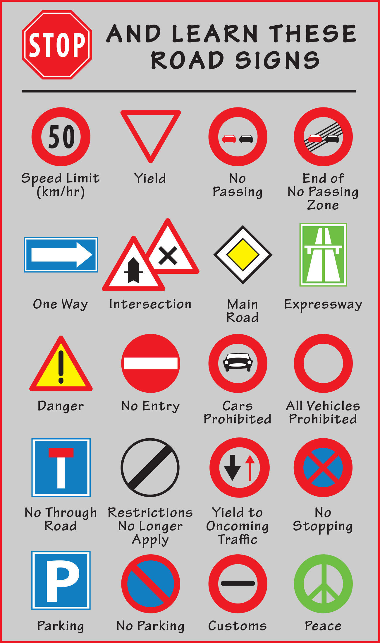
All of Europe uses the same simple set of road symbols It takes just a few minutes to learn them (see image). Many superhighway rest stops have local driving almanacs (or cheap maps) that explain common signs, roadside facilities, and exits.
Metric Distances
European countries (except the UK) use kilometers instead of miles. One kilometer is six-tenths of a mile. To convert kilometers to miles, cut the kilometers in half and add 10 percent of the original number (360 km = 180 + 36 = 216 miles; 90 km/hour = 45 + 9 = 54 mph — not very fast in Europe). Some people prefer to drop the last digit and multiply by 6 (if 80 km, multiply 8 × 6 = 48 miles), though this can be challenging with large numbers (340 km × 6 = ?). Choose whichever formula works for you.
When estimating how long a drive will take, figure you'll average 100 kilometers per hour on expressways (about the same as going 60 mph back home). Determining how much ground you can cover off the freeway is a crapshoot. I use a trick an Irish bus driver taught me: Figure a minute for every kilometer (covering 90 km will take you about an hour and a half). Double that for slow, curvy roads, such as in Italy's Dolomites or along its Amalfi Coast.
Navigating by Road and Town Names
Study the roads and major interchanges you'll be using before you set out. If you're headed for a small or midsize town, know which big city is nearby (and most likely to be signposted) to keep you headed in the right direction.
In some countries, road numbers can help you find your way: For example, take road A-1 to London, then B-4051 to Bristol, then C-456 to Bath. Normally, the more digits the road number has, the smaller it is; so in Britain, M-1 is a freeway, A-34 is a major road, and B-4081 is a secondary road. In other countries, local signs ignore the road numbers (which can change along the way), so it's necessary to navigate by town name. Signs are often color-coded: yellow for most roads, green or blue for expressways, and brown for sightseeing attractions.
Most international European expressways are designated with an "E" (similar to the "I" designation on American freeways), but they may also be labeled on maps and signs with their national letters (for example, the main route between Paris and Lyon is known as both A-6 and E-15).
Navigating in Towns and Cities
You can drive in and out of towns European towns fairly smoothly by following a few basic signs. Most places have signs directing you to the "old town" or the center (such as centrum, centro, centar, centre-ville, Zentrum, Stadtmitte). Most tourist offices, normally right downtown, are clearly signposted (i, turismo, VVV, or various abbreviations that you'll learn in each country). The tallest spire often marks the center of the old town. Park in its shadow and look for the tourist information office. When leaving a city, look for "all directions" signs (toutes directions, alle Richtungen, etc.) pointing you out of town.
When you reserve your hotel room, ask your hotelier — or at least check their website — for detailed directions on how to reach the place and where to park. If possible, figure out your arrival route before you enter the city limits. While some small towns helpfully post signs directing you to individual hotels, in many cases you're on your own. If your hotel is within a restricted driving area, ask your hotelier to register your car ahead of your arrival or direct you to legal parking.