Iceland’s Volcanoes
By Rick Steves and Ian Watson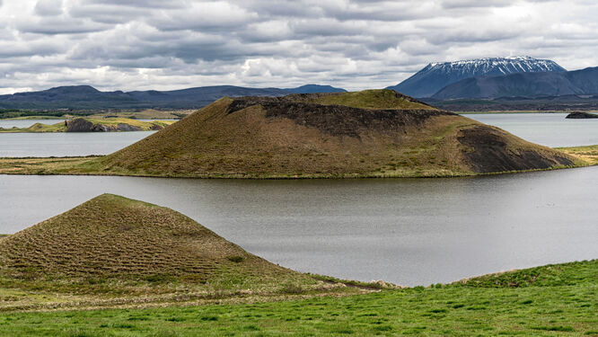
Many travelers come to Iceland hoping for a glimpse of a volcano. When the volcano called Eyjafjallajökull spewed ash into the atmosphere in 2010 — bringing European air travel to a halt — it grabbed the imagination of many.
Iceland is indeed one of the most volcanically active places in the world. Volcanic eruptions, ejecting liquid lava, gas, ash, cinders, and/or solid rock (the biggest rocks are sometimes called "volcanic bombs"), can last from a couple of days to several years.
The Reykjanes Peninsula, just south of Reykjavík, has seen some of Iceland's more recent eruptions, with frequent activity from 2021 to the present. The area's proximity to the international airport and the famous Blue Lagoon lava-rock spa has grabbed international headlines. However, the area is largely uninhabited (except for the tiny town of Grindavík, which has been intermittently threatened by lava), and so far the eruptions have not caused difficulties for travelers.
Grímsvötn, a hard-to-reach volcano under the Vatnajökull glacier (in southeast Iceland), has been one of Iceland's most active; it last erupted in 2011. Bárðarbunga, another volcano under the same glacier, began rumbling awake as recently as 2014–2015. The more famous Eyjafjallajökull, on the South Coast, made news in 2010. Other well-known Icelandic volcanoes include Hekla (once nicknamed the "Gateway to Hell"), Krafla, Askja, and Katla, whose proximity to coastal hamlets makes it especially dangerous. Katla erupts about once a century, and the last time was in 1918 — so many think it's due. You can check the current status of Katla, and all her siblings, at the Catalog of Icelandic Volcanoes.
Of the roughly 130 volcanoes in Iceland, the most common type is the stratovolcano — the classic cone-shaped peak with explosive eruptions that form a crater in the very top (such as Hekla and Katla). There are also a few dormant shield volcanoes — with low-profile, wide-spreading lava flows; one called Skjaldbreiður is near the Golden Circle. Eruptions from fissure vents — long cracks in the earth's crust — are also common in Iceland, such as the recent Sundhnúkur eruption, the 2014 eruption in the Bárðarbunga volcano's Holuhraun lava field, and the destructive Laki eruptions in the 1780s.
Yet the odds that a volcano will be erupting during your visit are low. When eruptions do happen, they tend to be short-lived. Once an eruption site is deemed safe, authorities may designate some long-distance trails that hardy adventurers can safely hike for a better look at flowing lava. But the chances that you'll be able to pull over your car for an "easy" look at a river of molten rock are slim.
Even when there are no active eruptions, a variety of volcanic sights make it easy and engaging to learn more about the island's unique geology.
The Westman Islands themselves, an archipelago just off the South Coast, are the country's most interesting volcano-related sight, where you can see the results of some of Iceland's most spectacular recent volcanic activity. Between 1963 and 1967, the islet of Surtsey — which, on a clear day, you can see from the main island of Heimaey — literally rose from the Atlantic Ocean. On Heimaey, in the town of Vestmannaeyjar, you can see streets that dead-end at steep walls of volcanic rock: a result of a surprise eruption one night in 1973, when the eastern part of town was gradually swallowed by flowing lava. A few lucky houses are still surrounded on three sides by jagged cliffs. And Vestmannaeyjar's Eldheimar Museum, with Iceland's best explanation of volcanic activity, is built around a house buried by lava — letting you peek into a family home forever trapped in rock.
Several other museums provide enlightening background on Iceland's volcanoes — most notably the high-tech and entertaining Lava Center in Hvolsvöllur (on the South Coast), the Katla Visitor Center (also on the South Coast), the Forces of Nature exhibit at the Pearl in Reykjavík, and the Lava Show (both in Reykjavík and Vík), where you can see real molten lava flow, drip, pop, and cool, while learning about the science behind it.
Iceland also offers several opportunities for subterranean volcanic exploration. While pricey, they're definitely memorable experiences and worth considering if you'd like an up-close look.
On the Inside the Volcano tour at Þríhnúkagígur, a cinder cone in the Bláfjöll mountains southeast of Reykjavík, you can descend into the vast magma chamber of a volcano that erupted about 4,000 years ago. The nearby Lava Tunnel tour of Raufarhólshellir, the fourth-longest known lava tube in Iceland, takes you past the extensive tunnel's colorful geological formations. True rock nerds should consider the more remote Víðgelmir Cave, two hours north of Reykjavík, for its multicolored layers of basalt lava and remarkable formations.
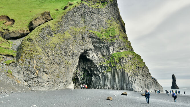
But you don't need to go underground to appreciate Iceland's volcanic history — the island's entire surface is made of volcanic rock, most of it basalt (the igneous rock that forms when lava cools). Iceland's towering cliffs and jagged islands and skerries are all made of basalt, as are the miles of lava fields you're sure to see around Keflavík Airport and the Blue Lagoon. When basalt cools in particular ways, it forms the hexagonal rock columns that you can see at Reynisfjara (on the South Coast), near Dettifoss and Stuðlagil (in the north), and many other places.
New lava is shiny and oily-looking, while old lava loses its gleam. Old lava fields — recognizable by their unique, bumpy appearance — are often covered with a fuzzy layer of Icelandic moss.
At the lake called Mývatn, in the north, you can see pseudocraters (also called "rootless cones"), which form after lava flows cover a pond or marsh. The water underneath the lava boils and a giant bubble breaks through the lava, leaving a crater-like depression.
So why does Iceland have so many volcanoes? Iceland is located on the long, mostly underwater Mid-Atlantic Ridge — the meeting point of the Eurasian and North American tectonic plates. As the two tectonic plates move apart, magma from the earth's mantle rises to the surface (we start calling it "lava" when it erupts). Iceland is located on a mantle plume, where magma is especially close to the surface, which explains why land formed in this spot in the middle of the ocean, and not elsewhere along the tectonic ridge.
Ian Watson is a co-author of the Rick Steves Iceland guidebook.